Nigeria at a Glance
The Federal Republic of Nigeria is Africa’s most populous country and a major economy in West Africa. The facts below offer a concise introduction for visitors, partners, and the Nigerian community abroad.
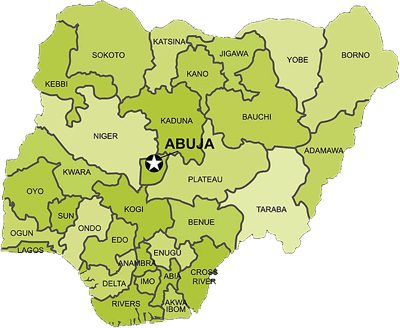
- Land area 923,766 sq. km
- Population About 206 million (2020 estimates)
- Capital Abuja
- Government Federal republic: Federal Government, 36 States, and 774 Local Government Areas
- Official language English
- Time GMT+1
- National Day 1 October
- Main languages Hausa, Igbo, Yoruba, and many others
- Religions Christianity, Islam, and traditional belief systems
- Currency Naira (NGN) and kobo (100 kobo = 1 naira)
- Weights and measures Metric
Cities and industry
Major commercial and industrial centres include Lagos, Onitsha, Kano, Ibadan, Port Harcourt, Aba, Maiduguri, Jos, Kaduna, Warri, Benin City, and Nnewi.
- Refineries and petrochemicals Kaduna, Warri, Port Harcourt, Eleme, Eket
- Iron and steel Ajaokuta, Aladja, Warri, Oshogbo, Katsina, Jos
- Fertilizer Onne (Port Harcourt), Kaduna, Minna, Kano
- Liquefied natural gas Bonny
- Aluminium Ikot Abasi, Port Harcourt
Transport and energy
- Main seaports Lagos (Apapa, Tin Can Island), Warri, Port Harcourt, Onne, Calabar
- Main airports Lagos, Abuja, Kano, Port Harcourt, Enugu, Kaduna, Maiduguri, Ilorin, Jos, Owerri, Calabar, Yola, Sokoto
- Roads Extensive intercity paved network, including dual carriage express trunks
- Railways Two main lines linking south-west to north-east and south-east to north-west (about 3,505 route km)
- Hydroelectric Kainji, Jebba, Shiroro
- Thermal and gas Egbin (Lagos), Ughelli, Afam, Sapele
For culture, geography, history, and government, see the other pages under About Nigeria.